Sometime in the next few weeks (it may already have happened by the time you read this) the wind will swing into the southeast, the flags along Marine Drive will snap to attention, and Cape Town will resume its oldest argument: whether the Cape Doctor is a blessing or a punishment. September is when the season’s first proper southeasters arrive, a warm-up act for the main event that runs through high summer. If you live in Table View you know the drill. If you’ve just moved here, or you’re planning a December visit, what follows is the explanation locals give over coffee, minus the folklore and with the actual numbers.
First, the name. Sailors and settlers called it the Doctor because it seemed to scour the settlement clean, blowing away smoke, stink and, so the story went, disease. The diagnosis was pre-scientific but the observation was sound: the southeaster is a dry wind that arrives with blue skies and leaves the air scrubbed. That is also why it gets better press than Cape Town’s winter northwesters, which can be every bit as strong but arrive wrapped in rain.
It starts a thousand kilometres out to sea
The engine of the whole thing is the South Atlantic High, an enormous dome of slowly sinking air that sits over the ocean west of the country. In winter it drifts north, opening the door for the cold fronts that give the Cape its rain. In summer it slides south and parks closer to us, and that changes everything.
Air flows out of a high-pressure system and, in the southern hemisphere, it curls anticlockwise as it goes. Sit on the eastern flank of that great slow spiral, which is exactly where Cape Town sits in summer, and the flow arrives at your door from the southeast. Meanwhile the Karoo interior is baking. Hot ground heats the air above it, that air rises, and a lazy area of low pressure forms over the middle of the country.
Wind is just air running downhill from high pressure to low, and the steeper the slope between the two, the faster it runs. Meteorologists call the slope a pressure gradient. When the South Atlantic High ridges in close behind the peninsula and the interior trough deepens on a hot day, the gradient across the Western Cape tightens like a drawn bowstring, and the southeast flow goes from breeze to gale. No mystery, no malice. Just physics operating at the scale of an ocean.
The mountains turn a breeze into a gale
If the story ended there, we’d have a stiff but unremarkable trade wind. The reason Cape Town’s version is famous is the furniture in its path. The wind comes ashore across False Bay and immediately has to deal with two walls of rock: the Hottentots Holland range to the east and the Table Mountain chain to the west. Squeezed through the gap between them, it does what water does when you put your thumb over a garden hose: the same volume of air forced through a narrower space has to speed up. It then accelerates across the Cape Flats, splits around Table Mountain, and rejoins in Table Bay having been compressed, bent and generally aggravated the whole way.
That is the wind that reaches us. By the time it crosses the bay to Bloubergstrand it blows almost parallel to the beach (side-shore, in kitesurfing language), which is the single geographic accident that turned an ordinary stretch of West Coast sand into one of the most famous kiting venues on earth. It’s a large part of why the area works the way it does, something we’ve covered in detail in our complete local’s guide to Blouberg and Table View.
How strong does it actually get? The South African Weather Service’s routine summer warnings for this coast talk about southeasterly gusts up to 90 km/h, and that’s a normal bad day, not a disaster. The record book is wilder. SAWS lists Cape Point as the windiest weather station in the country. The air there is calm for only about 2% of the hours in a year. And during the notorious April 2024 blow, a so-called black southeaster driven by a cut-off low, gusts around Cape Town and the Boland reached roughly 135 km/h, figures that UCT’s climate researchers noted were generally stronger than the famous Cape Storm of June 2017. The Doctor has range.
The tablecloth is the wind made visible
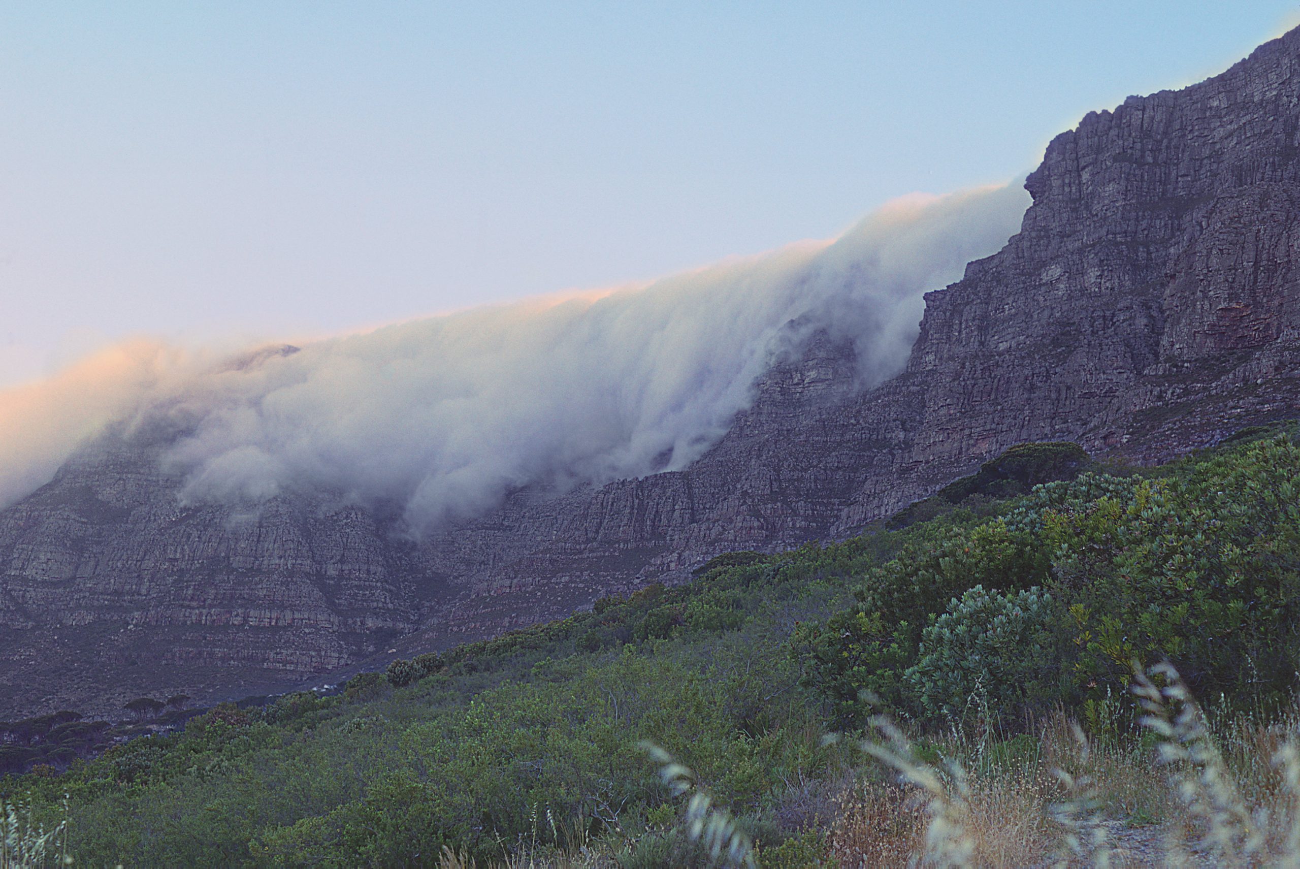
You can watch this entire process happen from the Table View beachfront, because the southeaster paints itself onto the mountain. As the flow crosses False Bay it picks up moisture off the water. When that damp air slams into the back of Table Mountain it has nowhere to go but up, and rising air cools. Cool it enough and its water vapour condenses into cloud, the same reason your breath fogs on a cold morning. The result is the tablecloth: a smooth white sheet that forms on the summit and pours endlessly over the front face without ever reaching the city below.
The vanishing act is the elegant part. As the cloud spills down the northern side it descends into warmer air, warms up itself, and evaporates partway down the cliffs. Hikers’ guides put the dissolving line at roughly 500 metres above sea level, about halfway down the mountain’s face. So the tablecloth isn’t a cloud drifting past; it’s a continuous conveyor, forming on one side and un-forming on the other, for as long as the wind feeds it. From Blouberg’s angle across the bay it looks serene. It is actually a gale, rendered in water vapour.
It does not blow every day
Here is the myth that needs retiring. Visitors read about the Cape Doctor and picture three unbroken months of wind. Locals sometimes talk as if that’s true. It isn’t. The southeaster blows in spells: typically a couple of days of strong wind while the high ridges in behind the peninsula, then a lull as the pattern relaxes, then another spell when the next ridge arrives. Even in the depths of December there are still, glassy mornings when Table Bay looks like poured metal and you’d swear the wind was a rumour.
Two more corrections while we’re at it. One: the southeaster is not automatically Cape Town’s strongest wind. The winter northwesters that ride in on cold fronts can be every bit as fierce; the Doctor simply gets more attention because it blows on beautiful days when everyone is outside to feel it. Two: it isn’t always dry. A few times a season a cut-off low over the country turns the flow into a black southeaster, the same direction but loaded with low cloud and rain. The April 2024 storm was the extreme version. If the wind is from the southeast and the sky is grey, that’s what you’re looking at.
What the calendar and the clock actually say
The season has a shape. The first real blows arrive in September and October as the high starts its southward migration: enough to remind everyone what’s coming, with genuine calm weeks in between. November through January is the heart of it, when the spells come most frequently and last longest; several published guides single out November as the most relentless stretch. February usually still delivers, but the grip loosens, and by late March and April the Doctor is packing up as the high drifts north and the first fronts of autumn nose in.
The daily rhythm matters just as much, and it’s driven by that interior heating we started with. Overnight the land cools and the pressure gradient slackens, so mornings are routinely the quietest part of the day even mid-season. As the sun climbs and the land heats, the gradient tightens again and the wind builds through late morning, usually peaking in mid to late afternoon. Evenings often ease off — though during a strong synoptic spell, when the big pressure pattern itself is doing the work, it will howl straight through the night and dawn brings no mercy.
The practical translation for this side of the city: on a southeaster day, the beach walk, the sea swim, the run along the promenade all belong to the morning. By 15:00 the beach at Kite Beach is a sandblasting cabinet at ankle height and the only happy people on it are attached to kites.
A rule of thumb to finish
Everything above compresses into one piece of street wisdom: if it’s blowing at breakfast, it will be howling by mid-afternoon, so check early and believe what you see. A calm 07:00 with a bare mountain often means a genuinely calm day. A tablecloth forming over the mountain, or a morning reading already in the twenties (km/h) on our live beachfront weather station, means the machine is switched on and the afternoon will only turn the dial up. Plan your still-weather errands before ten, give the Doctor the afternoon, and you’ll get along with this wind just fine — most of us eventually do.
Sources & further reading
- Cape Doctor — Wikipedia
- The South Easterly Explained — North Kiteboarding / North Action Sports
- The Cape Doctor — Cape Town Magazine
- More context on Cape Town storms — Climate System Analysis Group, UCT
- What are the temperature, rainfall and wind extremes in SA? — South African Weather Service
- The Tablecloth of Table Mountain — Hike Table Mountain
- Violent and gale-force winds — City of Cape Town
Featured image: Cape Town, Table Mountain, Table Cloth by KodachromeFan, via Openverse (wikimedia) — BY-SA 3.0